Lee's Ferry
Lee's Ferry (also known as Lees Ferry, Lee Ferry or Saints Ferry) is a real location - it is a site on the Colorado River about 7.5 miles (12 km) southwest of the town of Page, Arizona, 9 miles
(14 km) south of the Utah-Arizona border, and about 15 miles (24 km) downstream of Glen Canyon Dam.
Contents
History
The Lee's Ferry name comes from the fact that it is the former location of a river crossing rowboat ferry operation that was established in 1871 by John Doyle Lee (September 12, 1812 - March 23, 1877), a Mormon settler who had nineteen wives, sixty-seven children and was a principal in the September 1857 Mountain Meadows Massacre of roughly 120 victims (some reports state 140 victims).
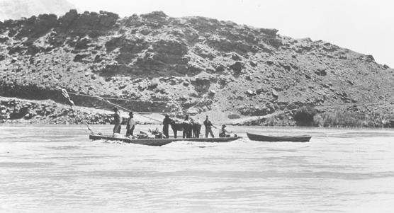
Mr. Lee, his compatriots and his successors operated the ferry boats for just over 55 years, from 1872 until 1928. An old photo of the ferry in use The boat is attached to the over-river cable by pulley blocks. By having a tight line at one end of the ferryboat (the left end in the photo) and lengthening the line on the other end (i.e. setting an angle of the boat to the water flow of about 45 degrees) the boat would be pushed across the river by the rivers own flow. To return to the other side the pilot would exchange the lengths of the lines and the flow would push the boat in the opposite direction.
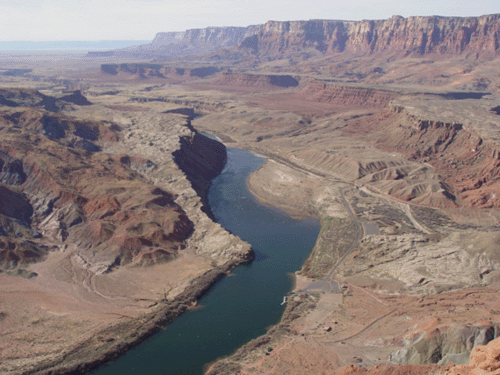
Looking down at Lees Ferry from the cliffs above. The ferry site (and the boat ramp today) is the "V" shaped area on the right hand bank (which is north) about 1/3 of the way up from the bottom of the photo.
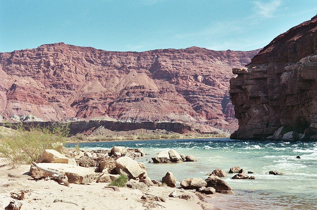
Upstream view of the Colorado River from Lee's Ferry
The state of Arizona decided that a bridge was needed as adverse weather and river flooding regularly prevented operation of the ferry, plus the ferry could not handle vehicles. In 1927 construction on the first Navajo Bridge began across Marble Canyon 4.3 miles (7 km) to the south. When the bridge was completed two years later, in 1928, the actual ferry was closed, and both the cable and all of the supporting poles were removed. Click here for a photo of the 1928 bridge
In 1990, however, it was decided that the original bridge was undersized for the traffic flow of the day plus had insufficient weight carrying capability. Due to the design and construction of the original bridge any upgrading and strengthening it was logistically and technically impractical so it was decided to simply build a new, parallel bridge. Construction of the new bridge started in 1994 and took seven months to build. Once it was placed in service the old one (the northern one) was decommissioned - it is now used only as a footbridge and observation deck. The new bridge parallels the old spanning over 834 feet (254 m) of the gorge at a height of 467 feet (143 m) above the water. From the Navajo Bridge to Lees is about 5 miles (8 km). Click here for a Google Maps photo of the Navajo Bridges

Location
Lee's Ferry on the Colorado River is considered the dividing line between the Grand Canyon National Park (downstream) and the Glen Canyon National Recreation Area upstream from Lee's to the Glen Canyon Dam (the National Park Service).
Today, Lee's Ferry consists of a large launching ramp, a boat dock and a number of historic stone buildings all on the north side of the river. There is no longer any ramp or anything else on the south side. The launching ramp is the only place in the Grand Canyon National Park where you can actually drive right up to the River. A National Park Service ranger station and campground is a little bit up the road from the actual launching ramp. A restaurant, service station, post office and store are available at the town of Marble Canyon, 3.5 miles south of Lees Ferry.
Click here for a Google Maps photo of Lee's Ferry The road from the highway comes in from the left side, and after the rafts launch they float downriver - towards the left.
Most of the commercial rafting trips running the Colorado River through Grand Canyon National Park use Lee's as their "put-in point" or starting point, and consider that location to be "Mile Zero" - every other location is referenced by the distance downstream from Lee's. For example, at mile 88.1 you find Phantom Ranch.
The next opportunity to cross the Colorado River downstream (southwest) of Lees Ferry is Boulder Dam, 225 miles (362 km) below the Grand Canyon.
Wes Boyd had his own trip through the Canyon starting at Lee's. It is documented on the pages at Big Guy in the Grand Canyon.
In Story
In the Spearfish Lake Tales universe the only mention of Lee's is as a river rafting launch site used by several rafting companies. In the real world it's that and more: a boat dock and also a fishing site. The three most common species are rainbow, brown and cutthroat trout. As a raft launch site, during the busy part of the commercial raft trip season some 250 people are launched on rafts every day.
Lee's appears in several of Wes's books, including Dawnwalker, Alone Together, Blue Beauty, Magic Carpet, Canyon Fires, River Rat, Growing Together, Icewater and the Alien and Pulling Even. Mark and Jackie fly over the Grand Canyon in Chapter 21 of Rocinante, but Lee's is not mentioned.
In Chapter 20 of the book Magic Carpet Lee's is described as:
Eventually they turned off the main highway, crossed a bridge high over the river, then a little farther on turned and descended to Lee’s Ferry, where the trip would start, the last place that the river can be approached at water level by road for 225 miles. Lee’s Ferry was not large, just a paved parking lot with a wide ramp to the river, which had a few green tamarisk trees alongside.
In Chapter 3 of River Rat Lee's is described as:
It was a fairly long ride out to the put-in at Lee's Ferry, close to three hours on roads that weren't very good pavement. They quickly got out of the pine country around Flagstaff, and were soon in a brushwood desert, running much of the way through a valley with steep red walls and talus slopes lying at their bases. Here and there were tiny villages -- they were going through the Navajo reservation before long -- and in several places along the road were collections of rude souvenir stands, mostly empty. It seemed a long, long way from North Carolina. Eventually, they turned off the main road and descended to Navajo Bridge -- actually, a pair of bridges, one now used only as a footbridge. As they passed over the vehicular bridge, they could see the green waters of the Colorado below, far down at the bottom of a canyon with nearly vertical sides. Shortly afterward, they turned off onto a side road and descended steeply, coming out at Lee's Ferry, the last place to put rafts in before reaching the Grand Canyon. The place was named for a Mormon who had once run a rowboat ferry service across the river -- there was a lot more story than that, Crystal told her, maybe she'd have the time to tell it later.
Further on in the story...
Lee's Ferry proved to mostly be an asphalt parking lot, nestled between a cliff to the east, a cliff to the south, and a steep hill that the road wound down to the northwest. It was pretty, redrock country; there was a little fringe of tamarisk trees, and a river that seemed blue as the sky.
In Chapter 15 of River Rat we find that Al, Crystal, Jerry and Dan scatter Louise's ashes onto the river from the ramp at Lee's.
Towards the end of the last chapter of River Rat we find Pastor Jordan conducting two wedding ceremonies back to back on the ramp at Lee's - one for Crystal and Preach, and the second for Scooter and Jim.
Links
For a more detailed history of Lee's Ferry please visit these pages:
- the Lee's Ferry page at Wikipedia
- the Lee's Ferry page at Desert USA web site
- the Lee's Ferry page at the National Park Service web site (with photos)
- the Lee's Ferry history page at the National Park Service web site (with photos)
- Arizona Boating Locations Facilities Map
- Arizona Fishing Locations Map
- A U.P. native goes 'Into The Wild' (In this case U.P. refers to Upper Peninsula, as in Michigan, not Union Pacific railroad)